Equipment and certifications
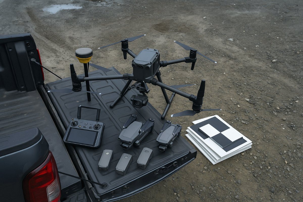
Technical buyers search by platform and sensor, so here is the inventory plainly, with the certifications that permit it to be flown the way we fly it. Three airframes, two base stations, a GNSS rover, AeroPoints ground control and the full processing pipeline are ours; the payload is configured to the job. Manufacturer specifications are quoted as published, with the conditions they were measured under stated.
What flies
DJI Matrice 350 RTK
The survey and inspection workhorse, and the aircraft any measurable job is flown on. IP55 rated, which matters on this coast, and carrying the RTK module that gives every image and laser return a precisely known origin.
| Max flight time | 55 min |
|---|---|
| RTK positioning, horizontal | 1 cm + 1 ppm |
| RTK positioning, vertical | 1.5 cm + 1 ppm |
| Weather rating | IP55 |
| Safety payload | ParaZero parachute |
The RTK figures describe how precisely the aircraft knows its own position in RTK FIX. They are not deliverable accuracy — that depends on the sensor, the flight height and the ground control, and is stated per job.
DJI Mavic 4 Pro
Quick to deploy and small enough for confined access, close-range inspection detail and documentation work. The right aircraft whenever the M350's footprint is more than the job needs, and the one most inspection days start with.
| Role | Inspection, media |
|---|---|
| Deployment | Under 5 min |
| Best for | Close detail, tight sites |
DJI Mini 4 Pro
Sub-250g. Its usefulness is regulatory rather than technical: it can work in places and around people where a larger airframe cannot, which makes it the answer for quick documentation on a constrained site or a fast look at something before committing a survey day to it.
| Class | Sub-250 g |
|---|---|
| Role | Constrained sites, recce |
| Deployment | Minutes |
Not a survey aircraft. Used for documentation and reconnaissance rather than for measurable deliverables.
The aircraft is chosen, not defaulted to
Operators with one aircraft fly every job on it, which means either bringing far more machine than a small inspection needs or attempting a survey on something that cannot hold the accuracy. Having three means the airframe is matched to the site: the M350 where the work has to be measurable, the Mavic 4 Pro where access and detail matter, the Mini 4 Pro where size is the constraint.
It also means a weather or serviceability problem on one aircraft does not cancel your flight day.
What makes it survey-grade
The aircraft is the least interesting part of a survey. What determines whether a deliverable can be trusted is the control beneath it — two base stations, a rover, and self-surveying targets that record their own position while we fly.
EMLID Reach RS2 — base and rover
A multi-band GNSS pair: one receiver established on site as the RTK base, the second used as a rover to observe ground-control targets and independent check points on foot. The check points are withheld from the processing solution, which is what makes the accuracy report a test rather than an assertion.
Running base and rover rather than base alone is the difference between a survey that is corrected and a survey that is corrected and verified.
DJI D-RTK 2
A second base station, tied directly to the M350's RTK module for real-time correction during flight. Having both systems means a job is never held up by one being on another site, and on longer programmes the two provide an independent cross-check of the correction itself.
Propeller AeroPoints
Self-surveying ground control targets. Each one is a GNSS receiver as well as a visual marker, so it logs its own position while the aircraft flies and is post-processed against reference networks afterwards. Laid out across a site, they establish the control network without a crew occupying each point in turn.
Their distribution, not the aircraft, is what determines whether a survey holds its stated accuracy across the whole area rather than only near the middle.
Conventional control targets
Physical targets set and observed with the RS2 rover where a project specifies its own control scheme, or where a point has to be tied to an existing survey monument rather than to a reference network.
ParaZero Safe-air parachute
A certified recovery system on the M350. It is the equipment that permits operations closer to people and structures than an unequipped airframe, which on a live construction site is frequently the difference between flying and not flying.
Payloads, matched to the job
The M350 is a modular airframe, so the payload is configured to the job rather than being a fixed feature of the aircraft. A survey gets the sensor the work actually calls for — a photogrammetric camera where that is the right measurement, LiDAR where canopy or terrain demands it, radiometric thermal where the question is heat rather than shape.
Specialist payload configurations carry a short scheduling lead time. We confirm the date at the quote stage rather than promising one and revising it. Standard photogrammetry, mapping and visual inspection work can usually be flown inside the week.
| Payload | Use | Published accuracy | Measured how |
|---|---|---|---|
| Zenmuse P1 | Photogrammetry, orthomosaics, 3D | 3 cm horizontal, 5 cm vertical absolute | Mapping mission at 3 cm GSD, 15 m/s, 75% front and 55% side overlap |
| Zenmuse L2 | LiDAR, bare-earth terrain | 5 cm horizontal, 4 cm vertical at 150 m | DJI laboratory conditions, RTK FIX, Optimize Point Cloud Accuracy enabled. With optimisation off: 8 cm horizontal, 4 cm vertical |
| Zenmuse H20T | Visual and radiometric thermal inspection | Not a measurement sensor | Thermal output is indicative; temperature readings depend on emissivity, distance and conditions |
Published accuracy figures are manufacturer laboratory specifications. Achieved accuracy on a real site depends on flight height, ground-control density, terrain and canopy, and is verified per job against independent check points and reported in the delivery note. Thermal output is indicative rather than a measurement: readings depend on emissivity, distance and atmospheric conditions, and are supplied for a qualified professional to interpret.
What your procurement team will ask for
- Transport Canada RPAS Advanced Operations certificate
- Licensed pilots with current flight reviews
- $5M aviation liability insurance, certificate on request
- WorkSafeBC clearance letter on request
- Site-specific safety plan and flight authorisation documentation
- Certified parachute recovery system for operations near people
- NAV CANADA airspace authorisation obtained before mobilisation
Who is operating it
Equipment is the easy half. The aircraft are flown by certified RPA pilots led by a commercial helicopter pilot with twenty years of rotary-wing experience, and the data is handled by a geomatics specialist with fifteen years in remote sensing. That is why the operating envelope on this page is stated as limits rather than as marketing: knowing what you will not fly in is a habit that comes from commercial aviation, not from a drone course. Meet the team.
Why Advanced Operations matters
Basic Operations certification does not permit flight in controlled airspace or near people. On Vancouver Island a great deal of commercially interesting ground sits inside the control zones around Victoria, Nanaimo and Comox, and most working construction sites have people on them.
An operator without Advanced certification either cannot fly your site, or is flying it without the authorisation they need. Both are your problem, not theirs, once something goes wrong.
We do not provide engineering assessments, structural evaluations or geotechnical opinions. Survey deliverables are for information and planning purposes and are not a legal survey.
Need our paperwork for a tender?
Ask on the quote form and the insurance certificate, WorkSafeBC clearance and certification details come back with the response.